Loos-en-Gohelle
Appearance
Loos-en-Gohelle | |
|---|---|
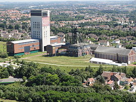
 Mine 11–19 at Loos-en-Gohelle | |
| Coordinates: 50°27′30″N 2°47′39″E / 50.4583°N 2.7942°E | |
| Country | France |
| Region | Hauts-de-France |
| Department | Pas-de-Calais |
| Arrondissement | Lens |
| Canton | Wingles |
| Intercommunality | CA Lens-Liévin |
| Government | |
| • Mayor (2023–2026) | Geoffrey Mathon[1] |
Area 1 | 12.7 km2 (4.9 sq mi) |
| Population (2022)[2] | 6,850 |
| • Density | 540/km2 (1,400/sq mi) |
| Time zone | UTC+01:00 (CET) |
| • Summer (DST) | UTC+02:00 (CEST) |
| INSEE/Postal code | 62528 /62750 |
| Elevation | 31–74 m (102–243 ft) (avg. 44 m or 144 ft) |
| 1 French Land Register data, which excludes lakes, ponds, glaciers > 1 km2 (0.386 sq mi or 247 acres) and river estuaries. | |
Loos-en-Gohelle is a commune in the Pas-de-Calais department in the Hauts-de-France region of France.[3]
Geography
[edit]It is a former coal mining town, three miles northwest of the centre of Lens. The two largest (184 m & 182 m) spoil heaps in Europe are in Loos-en-Gohelle, those of pits 11 and 19, and are visible for miles around. They are part of the mines of the Nord-Pas de Calais region that have become the 38th French site on the list of UNESCO World Heritage Sites as "a living and changing landscape".[4]
Population
[edit]| Year | Pop. | ±% p.a. |
|---|---|---|
| 1968 | 7,733 | — |
| 1975 | 6,958 | −1.50% |
| 1982 | 6,706 | −0.53% |
| 1990 | 6,561 | −0.27% |
| 1999 | 6,992 | +0.71% |
| 2007 | 6,816 | −0.32% |
| 2012 | 6,647 | −0.50% |
| 2017 | 6,751 | +0.31% |
| Source: INSEE[5] | ||
See also
[edit]References
[edit]- ^ "Répertoire national des élus: les maires" (in French). data.gouv.fr, Plateforme ouverte des données publiques françaises. 16 April 2024.
- ^ "Populations de référence 2022" (in French). The National Institute of Statistics and Economic Studies. 19 December 2024.
- ^ "INSEE commune file". Insee.fr. Retrieved 26 August 2024.
- ^ "The mines of the Nord-Pas de Calais make their debut as a UNESCO World Heritage Site". France.fr. Archived from the original on 18 October 2013. Retrieved 6 September 2013.
- ^ Population en historique depuis 1968, INSEE
External links
[edit]Wikimedia Commons has media related to Loos-en-Gohelle.


